
 Appliances
 Agri Inputs
 Auto Components & Accessories
 Beauty & Personal Care
 Electronics
 Fashion
 Grocery
 Gift Cards
 Home & kitchen
 Health & Wellness
 Vehicles & Automotives
 Books & Stationary
 Pet Care
 Toys & Games
 Contact Us
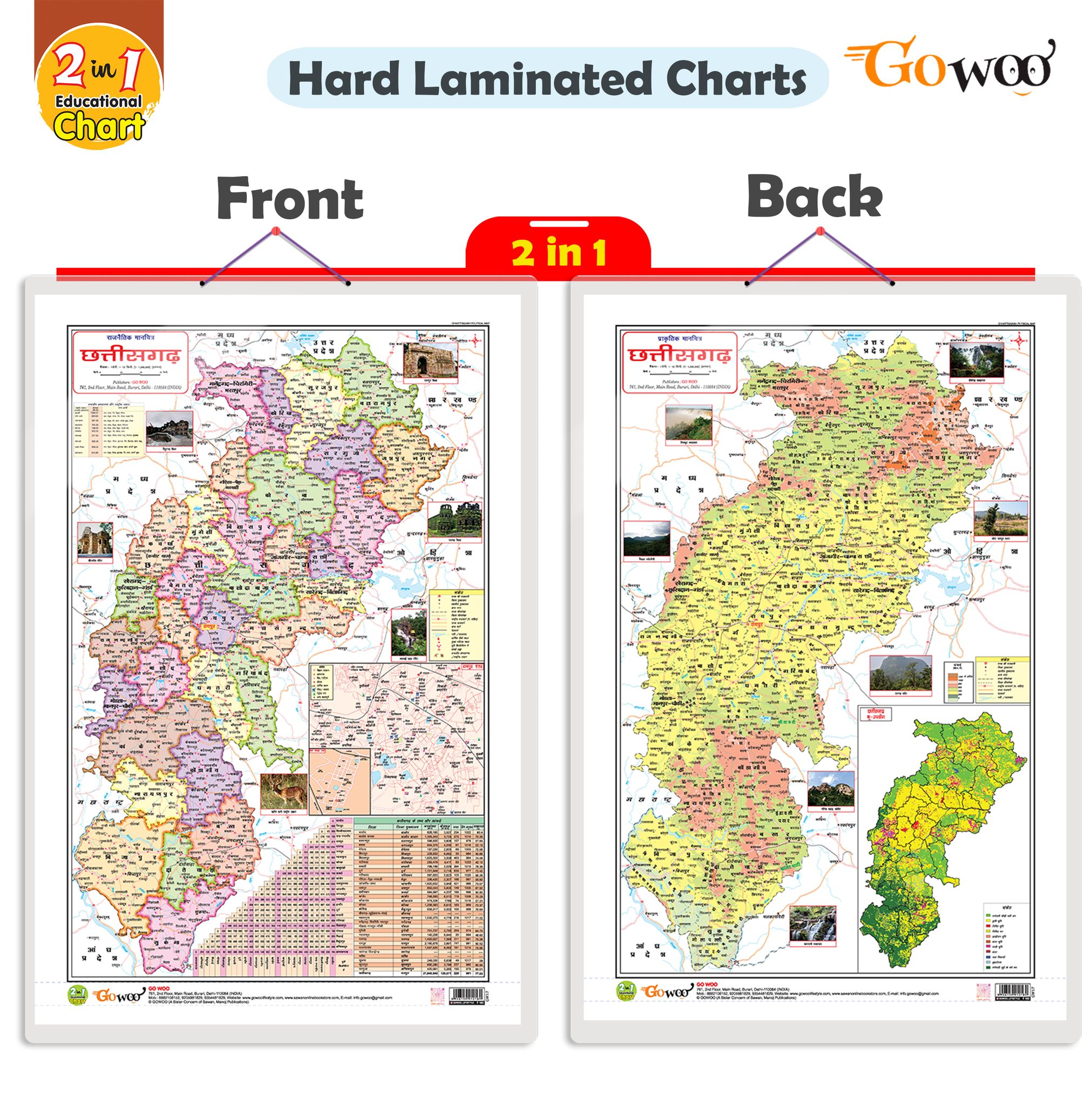
We are introducing our "2-in-1 Chhattisgarh Political and Physical Map" chart in Hindi. This chart is available in a size of 20x30 inches and is designed specifically for individuals interested in exploring Chhattisgarh's political and physical as...
Read MorePopular Categories
Support
Language
Our apps
2 IN 1 CHATTISGARH POLITICAL AND PHYSICAL Map IN HINDI Educational Charts | 20"X30" inch |Non-Tearable and Waterproof | Double Sided Laminated |Useful For Preparation Of SSC, UPSC, RRB, IES, and other exams
Key Attributes
| Country of origin | India |
|---|---|
| Net Quantity | 1 unit |
| Manufacturer or packer name | SURAJ SHARMA |
We are introducing our "2-in-1 Chhattisgarh Political and Physical Map" chart in Hindi. This chart is available in a size of 20x30 inches and is designed specifically for individuals interested in exploring Chhattisgarh's political and physical aspects.
The chart features two sections: a political map and a physical map. The political map provides detailed information about Chhattisgarh's administrative boundaries, districts, capitals, and major cities. This helps users understand the political division of the state.
The physical map highlights Chhattisgarh's mountain ranges, rivers, lakes, and other geographical features. It provides a comprehensive understanding of the natural geography of the state.
With this 2-in-1 chart, users can easily compare and analyse Chhattisgarh's political and physical dimensions. It is an essential resource for students, teachers, researchers, and anyone interested in learning about the state's geography.
The chart is printed on high-quality material to ensure durability and clarity of information. It is an educational tool that promotes a better understanding of Chhattisgarh's political and physical landscape.
| Country of origin | India |
|---|---|
| Common name | Political Maps |
| Net Quantity | 1 unit |
| Manufacturer or packer name | SURAJ SHARMA |
| Manufacturer or packer address | 761 MAIN ROAD BURARI DELHI |
| Manufacturing Date | Oct-95 |
| ISBN | 9788372410 |
| contact details consumer care | GOWOO, [email protected] |


